File:Grønland+grid.png

Size of this preview: 324 × 600 pixels. Other resolutions: 129 × 240 pixels | 329 × 609 pixels.
Original file (329 × 609 pixels, file size: 25 KB, MIME type: image/png)
Summary
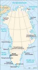
| Description | Map of Groeland with grid |
| Source | CIA World Factbook |
| Author | Translator , grid Ulamm 02:54, 14 December 2007 (UTC) |
| Other versions | de:Image:Gl-map.png |

|
This map image could be re-created using vector graphics as an SVG file. This has several advantages; see Commons:Media for cleanup for more information. If an SVG form of this image is available, please upload it and afterwards replace this template with
{{vector version available|new image name}}.
It is recommended to name the SVG file “Grønland+grid.svg”—then the template Vector version available (or Vva) does not need the new image name parameter. |
Licensing
This image is in the public domain because it contains materials that originally came from the United States Central Intelligence Agency's World Factbook.
|
 |
File history
Click on a date/time to view the file as it appeared at that time.
| Date/Time | Thumbnail | Dimensions | User | Comment | |
|---|---|---|---|---|---|
| current | 02:54, 14 Uvluiḷaq 2007 | | 329 × 609 (25 KB) | Ulamm | {{Information |Description=Map of Groeland with grid |Source=CIA World Factbook |Date= |Author=Translator de:Benutzer:Head, grid ~~~~ |Permission= |other_versions=de:Image:Gl-map.png }} |
File usage
The following page uses this file:
Global file usage
The following other wikis use this file:
- Usage on af.wikipedia.org
- Usage on als.wikipedia.org
- Usage on de.wikipedia.org
- Usage on de.wikinews.org
- Usage on el.wikipedia.org
- Usage on frr.wikipedia.org
- Usage on nds.wikipedia.org